| Welcome Visitor, Please Login or Register Now |
|
Tuesday, December 16, 2025 12:20 PM |
 |
mewsoft  |
| Administrator Team Member |
Posts: 5381  |
| Joined: 12-16-25 12:20 PM |
| Location: knxoville, TN, USA |
 |
|
 |
       |
|
| |
 |
|
| GeoMaker Version 2.0 Released Free- World GeoDatabase - Latitude, Longitude, Altitude For Entire World |
Edit Delete   Quote Quote |
| First Post Posted on: 12-01-13 08:57 AM |
  |
|
|
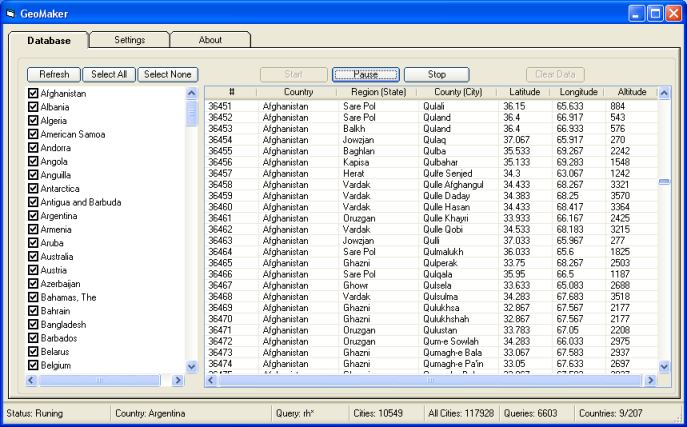
Greatings, Today we realsed a "GeoMaker" Version 2.0. Free download full version. Download Exe : http://www.mewsoft.com/download/GeoMaker.exe Download VB 6 Source Code: http://www.mewsoft.com/download/GeoMakerSource.zip Create
the GeoDatabase for the entire world. This program create the
geographical location Latitude, Longitude, and Altitude (Elevation) for
every city, village, region, state, county in the World. The program
crawls the data from the website www.heavens-above.com
which collect data from US Geological Survey for the USA (and
dependencies) and The National Imaging and Mapping Agency for all other
countries. The program is available as .exe and the source code in Visual Basic 6
This new version fixes the US cities data and some minor enhancements.
Thank you |
Mewsoft Support
www.mewsoft.com
|
|
|
|
|
|
|
| |
 Mewsoft and Mewsoft Logos are registered trademarks.
® Corporation. All Rights Reserved.
Copyright -
Privacy -
Terms of Use
Mewsoft and Mewsoft Logos are registered trademarks.
® Corporation. All Rights Reserved.
Copyright -
Privacy -
Terms of Use
| Page Load: 0.1082 Seconds |
|